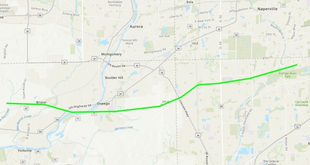
An EF-1 tornado moved through south Naperville Monday night, the National Weather Service has confirmed.
As the agency continues to investigate how many tornadoes touched down during the storms that racked Illinois and other parts of the Midwest earlier this week, damage assessments so far show a twister dropped down in Yorkville and continued to travel into south Naperville as the severe weather moved through the area.
As of Wednesday morning, the weather service had confirmed that at least 11 tornadoes occurred in northern Illinois and northwest Indiana as a result of the Monday night storms, said Brett Borchardt, a senior meteorologist with the National Weather Service in Romeoville. That number is “all but likely going to increase” as the agency surveys more storm damage, Borchardt said.
The tornado that in part passed through south Naperville carved a damage path of just over 19 miles. It was on the ground from about 8:55 p.m. until 9:18 p.m.
After touching down in Yorkville in Kendall County, it then continued eastward into Oswego and crossed into Will County near U.S. 30, Borchardt said. From there, the tornado went through neighborhoods just south of 95th Street across Route 59 in Naperville before continuing into Frontier Sports Complex, near Neuqua Valley High School. The last point the weather service tracked on the tornado’s path was just south of Walnut Ridge Park.
It may have continued further east beyond there, Borchardt said. Though confirmed, damage assessment of the event was expected to continue Wednesday and additional data may lengthen the tornado’s path, he said.
Peak winds of the tornado reached about 100 miles per hour. They were likely their fastest in Kendall County near Oswego, per damage surveyed by the weather service, Borchardt said. In Will County and Naperville, it appears that tornado winds were more consistently in the 70- to 80-mph range, he said.
The wind speeds classify the event as an EF-1 tornado, which are those that spin gusts of 86 to 110 mph, according to the weather service. For context, the tornado that tore through Naperville’s Ranchview neighborhood in June 2021 was an EF-3, which produces wind speeds between 136 to 165 mph. The strongest tornado would be an EF-5, with gusts above 200 mph.
The maximum width of Monday’s EF-1 was about 200 yards, Borchardt said. That’s a typical size for a tornado seen in northern Illinois, he said. Tornadoes can be as narrow as 10 to 20 yards to as wide as a mile. But generally, the twister that passed through Naperville, as well as the others confirmed by the weather service, seem to have been about the same intensity, Borchardt said.
Damage-wise, most of the impact from the Yorkville-Naperville tornado was to trees, the weather service found.
“That’s typically the damage we find with these EF-0 to EF-1 types of tornadoes, (damage) to trees,” Borchardt said.
Naperville’s tree canopy as a whole took a sizable hit Monday night. At a Naperville City Council meeting Tuesday, Public Works Director Dick Dublinski reported that about 10,000 of the city’s 70,000 trees lost limbs during the storms.
The city received more than 700 requests for help with post-storm tree cleanup, Dublinski added.
“It was a big storm. A very big storm,” he said. “It lasted only like 20 minutes. That one storm brought down a lot of limbs.”
Still, Dublinski said he’s “confident we can get it cleaned up.”
City offficials are not aware of any injuries from the weather event, City Manager Doug Krieger told the council.
“Although some residents and some businesses had some limited damage,” Krieger said, “there was not the kind of widespread damage that we had initially feared.”


