
Although investigations are still ongoing, the National Weather Service has confirmed the touchdown of at least five tornadoes in the Aurora area over the two storms last Sunday and Monday night.
The storm last Sunday night brought two tornadoes to the Aurora area, one in Elburn and one in St. Charles, according to the National Weather Service’s website. Monday’s storm brought three tornadoes to the area, with two in Sugar Grove and one that traveled from Yorkville to south Naperville, the service’s website about that storm showed.
No injuries or deaths have been attributed to any of the tornadoes in the Aurora area, according to the National Weather Service.
The tornado in Elburn hit at around 9:30 p.m. Sunday and was categorized as EF-1, which is moderate strength, with an estimated peak wind speed of 100 mph, according to a graphic from the National Weather Service about the tornado. The graphic showed the tornado, which had a maximum width of around 100 yards, started at around the Elburn Forest Preserve and traveled around five and a half miles roughly following the Union Pacific West rail line through La Fox to the edge of Geneva.
According to Kane County Undersheriff Amy Johnson, Elburn reported roughly 20 homes with some damage and between three and five homes with significant damage after last Sunday’s storm.
Last Sunday’s tornado in St. Charles hit at around 9:45 p.m. and was categorized as an EF-0, which is weak strength, with an estimated peak wind speed of 80 mph, according to officials. The tornado, which had a maximum width of 200 yards, started near West Main Street and headed southeast less than a mile to just past Randall Road.
Johnson said St. Charles had around a dozen homes and three multi-family residential buildings with damage after last Sunday’s storm.
On Monday, the strongest of the two tornadoes in Sugar Grove hit at around 8:50 p.m., according to a National Weather Service graphic. It was categorized as an EF-1 and had estimated wind speeds of 95 mph with a maximum width of around 300 yards.
That tornado started west of Sugar Grove and south of Route 30 near Big Rock Campground on Granard Road, the graphic shows. It traveled over 8 miles roughly east-northeast to just south of Aurora Central Catholic High School.
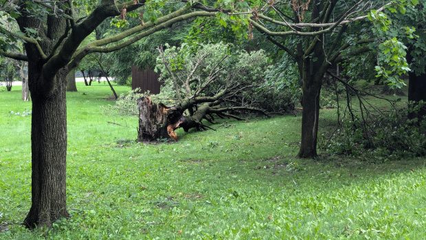
On Tuesday morning, a number of houses along Meadows Drive and Bastian Drive in Sugar Grove, which were in the path of the EF-1 tornado, could be seen with roof damage. Almost every yard along the two roads had fallen limbs or trees.
The weaker of the two Sugar Grove tornadoes started just after its stronger sibling at around 8:52 p.m., according to its National Weather Service graphic. The weaker tornado was categorized as an EF-0 with estimated wind speeds of 85 mph and a maximum width of around 250 yards.
This tornado traveled over 10 miles eastward, starting near Waubonsee Community College, passing over the Fox River in North Aurora and ending up near the Interstate 88 and North Farnsworth Avenue interchange, the graphic showed.
Fallen trees and leaning light poles could be seen south of North Aurora’s Oak Street on Tuesday. On Kingswood Drive, which the graphic showed was near the path of the EF-0 tornado, large limbs had fallen on one resident’s house, two vehicles and driveway, blocking the cars in.
The tornado that stated in Yorkville and ended up near Naperville, which hit at around 8:55 p.m. on Monday, traveled the farthest of any Aurora-area tornado at over 19 miles, according to a graphic from the National Weather Service. It was categorized as an EF-1, with wind speeds estimated up to 100 mph and a maximum width of around 200 yards.
It started just west of North Bridge Street in north Yorkville, passed through Bristol, over the Fox River and just south of downtown Oswego, the graphic shows. It then traveled east-northeast, passed through Naperville’s Frontier Park on Route 59 and finally ended just north of DuPage River Park in Bolingbrook.
Several large downed trees could be seen at the southern end of Oswego’s Main and Douglas streets on Tuesday morning.
In total, the National Weather Service has confirmed six tornadoes from last Sunday night’s storm and 22 tornadoes from Monday night’s storm in the Chicago area, the websites show.
Both storms were separate but similar weather events, according to David King, a meteorologist at the National Weather Service office in Romeoville. He said that while both storms brought heavy rain, high winds and tornadoes, last Sunday’s storm brought more rain while Monday’s storm brought higher winds.
Monday’s storm was also categorized as a derecho, which is a certain type of storm with wind gusts of at least 58 mph along most of its length and several separated 75 mph or greater gusts over an area at least 250 miles long, King said.
The two storms are still under investigation, according to King, but he said the “boots on the ground” part of the investigation is over. Data and reports from the two storms will continue to be reviewed and the websites dedicated to them, which can be found at weather.gov/chicago under the “News Headlines” section at the top of the page, will continue to be updated with new information as it becomes available, he said.
rsmith@chicagotribune.com