

Now is the time of year when families start thinking about a summer vacation. In the pre-internet era, that meant getting out the creased, dog-eared maps from the car’s glove compartment. Spread across a kitchen table, the maps fueled dreams of cross-country travel, unburdened by the reality of endless hours in an overstuffed vehicle.
Those vacation planners are indebted to Rand McNally. The Chicago area-based publisher pioneered road maps that were distributed at gas stations, beginning with Gulf Oil, in 1920. From time to time, the company had stores stocked with maps, atlases and guide books
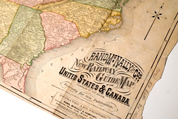
Road maps were a logical extension of Rand McNally’s business plan. It had published railroad maps since 1872. Still, it had to learn a new trick to produce road maps.
It isn’t difficult to match a railroad map to a railroad. Its freight and passenger cars carry the line’s logo. Stations and freight depots bear its name. But America’s early highways weren’t lined with numbered signs. So how would a motorist know where they were by following a wiggly line on a map?
John Brink, a Rand McNally cartographer, came up with a solution: Creating symbols for highways that were printed on the road maps and also put on signs attached to electrical and telephone poles along those roads. He won $100 in a contest the company ran for employees to develop new map products.
The company advertised Brink’s creation with the slogan “Follow the Blazed Trail,” Janice Petterchak reported in “Mapping A Life’s Journey, The Legacy of Andrew McNally III.”
The original cardboard signs were damaged by the weather. Others were pilfered by vandals, prompting a revised method: Painting the telegraph poles and advertising: “Follow the Painted Poles.”
If a map user got on a highway to their destination, the painted poles kept them headed the right way. But towns might have several highways, so a map user could choose the wrong one.
Because of that, another system of road identification was created by H. Sargent Michaels. His “Photographic Automobile Maps” provided pictures of intersections and turning points along a route. Rand McNally purchased the rights to it and in 1909 issued “The Rand McNally Photo-Auto Guides.”
“My mother and father took a busman’s honeymoon to Milwaukee,” Andrew McNally III, the company’s leader from 1948 to 1974, told the Tribune in 1982. “They took pictures of every turnoff from here to there. So came the Chicago-to-Milwaukee guide.”

A newspaper clipping in the family’s scrapbook continued the story: “He also took pictures of puzzling intersections, and when his company — Rand McNally & Co. — printed the road map resulting from his trip, white arrows in the pictures the honeymooners had taken showed which route to follow.”
Around 1917, numbers were substituted for symbols and painted poles, eventually leading to the numbering of all major roads in the United States.
Andrew III’s great-grandfather was Andrew McNally, an apprentice from Ireland hired in the late 1850s by William H. Rand who had a small print shop on Lake Street. At first, they did printing for the Chicago Tribune. But with an increasing number of railroad lines coming to Chicago, the partners decided to concentrate on the railroad industry.
The Tribune predicted, “It cannot but at once attain a wide circulation.”
But on Oct. 8, 1871, their building was destroyed by the Great Chicago Fire. McNally had the foresight, according to company lore, to bury two of their printing machines in the sand at Lake Michigan. When the fire ended, the company was able to resume business with the salvaged equipment and within a short time were printing 100,000 tickets a day.
In 1872, their first map appeared in the company’s “Railroad Guide.” Theirs was the first American company to produce maps from wax engravings — a method McNally learned in Ireland. Instead of creating new plates for updates, they could patch existing plates, dramatically reducing production costs.
Shortly, they added a touch of class by including verses by poet Robert Browning in the timetables of the Chicago and Alton Railroad.
They also inspired another artist. Helen Beck did a striptease act at Chicago’s 1933 World’s Fair. Cecil B. De Mille, the famed Hollywood director, said she needed a catchier name. Spotting a Rand McNally map on her agent’s wall, the stage name “Sally Rand” was chosen.
The company’s influence went well beyond helping vacationers navigate the nation’s roads. Charles Lindbergh, the first pilot to fly solo over the Atlantic Ocean, used Rand McNally railroad maps to navigate when flying over land. During World War II, a boatload of refugees fled Japanese-occupied Java and made it to Australia by charting the thousands of miles of their escape with a Rand McNally Pocket Atlas.
As the company prospered, Andrew III, whose father Andrew McNally II ran the company from 1933 to 1948, came of age thinking nothing of taking off for faraway places. During his freshman year at North Shore Country Day School in Winnetka, he visited an uncle in England. Subsequently he and a chum returned there. They had an audience with the prime minister and the prince of Wales. The lord mayor of London hosted a luncheon where they met authors and artists interested in British-American relations, according to Petterchak’s book.
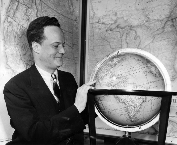

During World War II, Andrew III volunteered, and, after a quickie officer’s training course was commissioned a lieutenant in the Army Map Service. He was mildly surprised we won “with maps primarily based on outdated British cartography,” he told a reporter.
Andrew III succeeded his father as Rand McNally’s president in 1948. The company expanded greatly during his tenure at the top. Upon taking over, he decided to move the headquarters from their cramped building at Clark and Harrison streets to a spacious campus in Skokie. It became the largest mapmaker in the United States, printing tickets for airlines and publishing books, atlases and globes and even later expanded into storefronts.
The McNallys had majority control of the company and didn’t have to answer to stockholders with different ideas. Ward, the company’s founder, died in 1890, having been in ill health and selling his share of the business to the McNallys, and they never made a public stock offering.
In 1994, Andrew III said, tongue in cheek, that “the reason the business stays in the family, is that we never got rich enough to neglect it.”
But printed maps were becoming a thing of the past as computers became prevalent, and Andrew III’s successors didn’t share his reservations about selling the company piecemeal. In 1997, the family divested itself of the business. Its corporate offices in Skokie were sold in 2008 to Ida Crown Jewish Academy.
Ron Grossman is a columnist emeritus for the Chicago Tribune. His columns vary from social and political commentary to chapters in Chicago history. Before turning to journalism, Grossman was a history professor. He is the author of “Guide to Chicago Neighborhoods.”
Editor’s note: Thanks to Norman Fenske for suggesting this story. Have an idea for Vintage Chicago Tribune? Share it with Ron Grossman and Marianne Mather at grossmanron34@gmail.com and mmather@chicagotribune.com.
